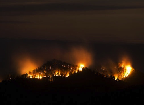
Cliff Creek Fire
Date of Detection: July 17, 2016
Current Size: 14,629 acres –An Infrared (IR) flight last night, which is a heat detection system used for fire mapping, provided more accurate mapping of the fire.
Location: 5 Miles North of Bondurant Wyoming
Legal Description: 43 x 14 x 21 Latitude, 110 x 29 x 28 Longitude
Cause: Lightning
Containment: 10%
Resources on Fire: There are currently 663 personnel on this incident, including the following resources:Crews: 17
Type I (Heavy) Helicopters: 4
Type II (Medium) Helicopters: 1
Type III (Light) Helicopters: 3
Engines: 26
Dozers: 1
Highway 189/191 is now open. For the SAFETY of the firefighters and highway travelers, no passing is allowed in passing zones within the fire area and no stopping along the roadway or parking in pullouts is allowed within the fire area.
Lava Mountain Fire
Fire Information: 307-455-4038
Fire email: 2016fireshoshonenf@gmail.com
Webpage: https://inciweb.nwcg.gov/incident/4864/
Facebook: https://www.facebook.com/US-Forest-Service-Shoshone-National-Forest
Total Acres: 5,488
Containment: 0%
Total Personnel: 492
Resources: 13 crews, 7 helicopters, 2 water tenders, 1 dozer, 29 engines, and 1 skidgen
Agency Jurisdiction: US Forest Service, Fremont County Fire Protection District & Dubois Volunteer Fire Department, and Wyoming State Forestry Division, Bureau of Land Management
Incident Command: Western Montana Type II Interagency Incident Management Team (IMT)
Today’s Message: Here are a few steps to take when leaving for an evacuation
· Shut all windows and door, leaving them unlocked
· Shut off gas at the meter, then turn off pilot lights
· Leave a light on so firefights can see you house in smoky conditions
· Shut off air conditioning
· Turn off propane
· Don’t leave sprinklers or water running, they can affect critical water pressure
· Locate pets and keep them nearby
· Prepare farm animals for transport and consider moving them to a safe location early
· For more information, check out https://www.readyforwildfire.org/Pre-Evacuation-Preparation/ or Fremont County’s FireWise Program athttps://www.fremontcountyfirewise.com/
Closures:
· Highway 26 remains open at this time with a no-stopping zone established in the vicinity of the fire. Forest Roads 513, 532, 542, 540, 542.1I, and 629 are closed. The Continental Divide Trail is closed from Sheridan Pass to Pilot Knob. And, Motorized Trails 10, 11, and 15 are also closed.
· Residents in the following areas are in evacuation stage “GO”: Long Creek Subdivision, Sheridan Creek Cow Camp, MacKenzie Highland Ranch, Timberline Ranch, and Teton Valley Ranch Camp.
· Additionally, the following areas are in pre-evacuation stage “SET”: Hat Butte Area, Sawmill Turnoff, Warm Springs Subdivision, Union Pass Area, Porcupine Subdivision, Falls Creek Campground, Roaring River Subdivision, Buckboard Subdivision, Laval Mountain Lodge, Double Bar J Ranch, Lava Creek Ranch, and Triangle C Ranch.
Whether you are directly affected by this incident or not, every resident in the surrounding area should have an evacuation plan in place. And, remember, if you feel concerned or threatened by fire activity, leave the area. Do not wait for someone to tell you; leave when you feel you need to.